


 Years-long Sebastian Inlet bridge replacement project begins Monday
STORY BY JON PINE (Week of May 28, 2026)
As 32963 residents know, it’s quite nice living on a subtropical island washed by saltwater on all sides – but bridges are essential to the lifestyle and the ones that connect the barrier island with the mainland have been wearing out.
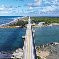
The antique drawbridge at the south end of the island was just replaced with a soaring new 4,500-foot-long span, the 17th Street Bridge in Vero has been under repair for years, now the Sebastian Inlet Bridge at the north end of the island that connects Indian River County with Brevard County needs to be replaced.
The $102 million Florida Department of Transportation project will start Monday, June 1, and continue for six years, according to FDOT officials. The crossing will remain open throughout the construction except in the case of emergencies, but there will be years of lane closures such as island residents have long seen on the 17th St. bridge.
The current 1,548-foot, two-lane span across the inlet was completed in 1964. It has been reconditioned twice over the years but was deemed structurally deficient by the state in 2018. Soon after, the FDOT began drafting plans for a new bridge.
“It has to be replaced,” Senior Project Engineer Bill Stuckey told Vero Beach 32963. “It is in very poor condition and very expensive to maintain.”
Stuckey and other FDOT engineers and consultants held virtual and in-person meetings last week to update the public ahead of project commencement.
Approximately 50 people showed up at the Environmental Learning Center to meet with FDOT officials on May 19.
“It seems like the public in general is excited about the project,” said Stuckey. “A lot of the feedback was positive, and most people understand that it’s a necessary improvement.”
Construction will begin on the south side of the span east of the existing bridge. The main questions people asked were about lane closures and whether work would continue after dark, said Project Manager Josh Baker.
The project, which is expected to wrap up in the spring of 2032, is designed and phased to always maintain traffic flow, Stuckey said.
However, motorists should expect periodic temporary lane closures between 7 a.m. and 5 p.m. Mondays through Thursdays and 7 a.m. to 1 p.m. on Fridays, Stuckey said. Flag operators will control traffic flow, he said.
Sebastian Inlet State Park will remain open on both sides of the inlet during construction, but some parking lots and other features will be closed for construction staging. That includes the main parking lot on the north side of the inlet, which will be fenced off until the project is completed.
Marine traffic through the inlet will be maintained during construction, aside from occasional temporary restrictions for safety reasons, said James Gray, executive director of the Sebastian Inlet District. The district will coordinate with FDOT to provide ample advance notice of any interruptions, Gray said.
Bridge construction also is not expected to significantly delay a project to rehabilitate the eastern portion of the north jetty, Gray said. Those repairs are set to begin in 2027 and take six to eight months to complete, he said. A 210-foot section of the jetty had its seawalls and supporting structure repaired and a new sidewalk was poured last summer and fall.
The new span will be 1,543 feet, 9 inches long, slightly shorter than its current length of 1,548 feet. At its apex, the bridge will have a clearance of 51 feet from the water in the inlet. The clearance for the current bridge is just 39 feet.
The bridge deck will still have just one northbound lane and one southbound lane, but each of those lanes will have 8-foot-wide shoulders. Outside of the shoulders will be a 12-foot-wide shared-use path, on both sides, for pedestrian and bicycle traffic. Three-foot-high concrete barriers will separate the shoulders from the shared-use paths.
Four-foot-high aluminum railings will be installed at the outer edges of the bridge, with three semi-circle look-out areas extending from each side, where people can stop to enjoy the views of the inlet and Atlantic Ocean out of the path of pedestrian and bicycle traffic.
“I think the bridge design is magnificent, a real work of art with the viewing areas,” said Indian River County Commissioner Laura Moss, whose district includes most of the barrier island. Moss also is a member of the county’s Metropolitan Planning Organization, which is responsible for transportation planning.
The local MPO has been working closely with the Space Coast Transportation Planning Organization and FDOT to oversee the project, Moss said. “It’s good to have that interface between the two counties that share this bridge,” she said.
Two observation decks will be constructed below the bridge – one is 232 feet long and extends from the north side and the other is 174 feet long and extends from the south side. Pedestrian traffic only will be allowed, not bicycles. Fishing will be permitted from both observation decks.
FDOT also will construct crosswalks on SR A1A at the state park’s north and south entrances and will reconfigure those entrances to add right turn entry lanes at each location to improve traffic flow. At the south exit, FDOT will add a 780-foot-long southbound acceleration lane so that vehicles leaving the park can speed up before merging into the southbound through-lane.
Project contractor, Texas-based Webber LLC, has the option to use stainless steel or fiberglass reinforcement materials in the concrete pilings and other supporting structures, Stuckey said. Both are more resistant to corrosion from saltwater than traditional steel rebar.
Site work is scheduled to begin Monday, June 1, with what FDOT calls grubbing, clearing a pathway through vegetation for A1A to be shifted to one side. Later, a trestle will be installed that extends about 100 feet into the waterway, which will allow cranes to access the inlet with equipment and materials.
Soon after, contractors will start building the bridge’s southern foundation, driving pilings and building supporting walls.
FDOT has other construction projects on the books along route 510 and U.S. 1 near the 510/U.S. 1 intersection, and some north island residents fear that all the simultaneous roadbuilding will create traffic flow problems.
FDOT is currently widening, from two lanes to four, a one-mile stretch of route 510 between 85th Street and County Road 512. That $24.9 million project is expected to continue through fall of 2028. FDOT may also widen 510 eastwards, including an overpass over U.S. 1. That project is still in the design stage.
Next, FDOT plans to resurface a little over four miles of U.S. 1 from 87th Street north to S. Sebastian Boulevard. That $9.2 million project is expected to commence in spring of 2027, finishing the following summer.
“With all of these projects happening at the same time, the traffic is going to be a nightmare,” said Bob Bruce who lives on A1A about 3 miles south of the inlet.
After the new bridge is complete, the 1964 concrete and steel structure will be demolished, and 3,500 tons of rubble will be barged to the Orchid Island Reef complex – a group of eight artificial reefs the county is creating in the ocean about 11 miles east and south of the inlet. Coastal Conservation Association will pay $110,000 – about half the cost to have FDOT barge the debris to the reef site instead of transporting it to a landfill. The county will pick up the rest of the cost.